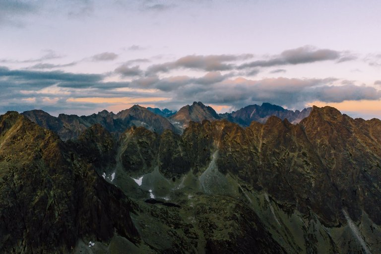
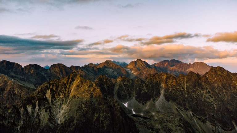
Well known in Poland as a destination for climbing expeditions - Mięguszowieckie peaks. I took the photos from a drone during sunset when I spent the night on the Bystra Ławka pass. I was hidden between the rocky towers, so I raised the drone to see a beautiful sunset on the ridge.
Mięguszowieckie Peaks (Slovak: Mengusovské štíty) - a group of three huge peaks on the Polish-Slovak border, in the main ridge of the Tatra Mountains separating the Rybi Potok Valley and the Mięguszowiecka Valley. The highest of them is Mięguszowiecki Peak (2,438 m, the second highest peak in Poland), rising above the surface of Morskie Oko, in front of the shelter. To the east there are: Mięguszowiecki Szczyt Middle (2,393 m) and Mięguszowiecki Peak Black (2,410 m), towering over Black Pond under Rysy.
Mięguszowiecki Peaks got its name as the peaks dominating the Mięguszowiecka Valley, and indirectly from the village of Mięguszowce located in the Spiš Podtatra Mountains. This name was given already in 1852 by Antoni Hoborski. In the past, the massif was also called Hruby Wierch, and in German since 1891 Chalubinski–Spitze (Chałubiński peak)
The 900-meter-high northern walls of Mięguszowieckie Peaks are a place often visited by mountaineers. In the climbing community they are colloquially called Mięgusze. The peaks have some of the largest walls in the Tatra Mountains, and their peaks are not accessible by tourist trails. The easiest access is to Mięguszowiecki Peak Black, while to Mięguszowiecki Peak Great from Przełęcz pod Chłopkiem there is a difficult route along the boulders, inaccessible to tourists.
Doskonale znane w Polsce jako cel wspinaczkowych wypraw- Mięguszowieckie szczyty. Zdjęcia zrobiłem z drona podczas zachodu słońca kiedy nocowałem na przełęczy Bystra Ławka. Byłem schowany pomiędzy skalistymi wieżami, dlatego podniosłem się dronem żeby ujrzeć piękny zachód słońca na grani.
Mięguszowieckie Szczyty (słow. Mengusovské štíty) – grupa trzech potężnych szczytów na granicy polsko-słowackiej, w głównej grani Tatr rozdzielającej Dolinę Rybiego Potoku i Dolinę Mięguszowiecką. Najwyższy z nich jest Mięguszowiecki Szczyt (2438 m, drugi co do wysokości szczyt Polski), wznoszący się nad taflą Morskiego Oka, na wprost schroniska. Kolejno w kierunku wschodnim znajdują się: Mięguszowiecki Szczyt Pośredni (2393 m) oraz Mięguszowiecki Szczyt Czarny (2410 m), górujący już nad Czarnym Stawem pod Rysami.
Swoją nazwę Mięguszowieckie Szczyty zyskały jako wierzchołki dominujące ponad Doliną Mięguszowiecką, a pośrednio od położonej na spiskim Podtatrzu wsi Mięguszowce. Nazwę tę podawał już w 1852 Antoni Hoborski. Dawniej nazywano masyw także Hrubym Wierchem, a w języku niemieckim od 1891 Chalubinski–Spitze (szczyt Chałubińskiego)
900-metrowe północne ściany Mięguszowieckich Szczytów są miejscem często odwiedzanym przez taterników. W środowisku wspinaczy potocznie nazywane są Mięguszami. Szczyty mają jedne z największych ścian w Tatrach, a wierzchołki ich nie są dostępne szlakami turystycznymi. Najłatwiejszy dostęp jest do Mięguszowieckiego Szczytu Czarnego, natomiast na Mięguszowiecki Szczyt Wielki z Przełęczy pod Chłopkiem prowadzi trudna Droga po Głazach, niedostępna dla turystów
My photographic equipment:
Sony A6000 with Sony E 18-105
Dji Mini 2
Samsung S10e
You can find me on instagram:
Lifestyle, travels and photos
Pictures of people, commercial
Amazing shots and lighting. Looks like a great entry for the contest!
Yes, I choose good candidate :)
That light was amazing
These mountains look amazing at golden hour!