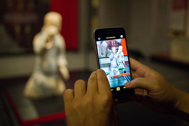
Picture from: https://www.pcah.us/news/augmented-reality-brings-2200-year-old-chinese-terracotta-warriors-life-franklin-institutes
Museum usually leaves people an impression of rigidity and detachment, which impedes the thorough access of publics to the knowledge. However, knowledge in the museum is not unfathomable but just intricate in most of time. In that case, the presentation of content decides the quality of communication. How to embody maximum information in the limited museum space? How to approach the audience full-sensorily to the historical items? Maybe augmented reality (AR) is the answer.
The use of augmented reality in a public space only requires an additional viewing interface. Through the screen, users basically enter a new dimension that contains more directional and detailed information about the displayed items. The conduct flexibility enables users to engage in the stories of the objects with a multisensory experience, which motivates them to learn more about the historic items. Let’s check out some major technologies currently used by museum to conduct AR.
Simultaneous Localization and Mapping (SLAM)
Widely used in autonomous platform like self-driving cars and drones, simultaneous localization and mapping technology helps autonomous systems to track the location of an agent, and simultaneously create a map of the unknown environment for the agent to function. This technology is well used by museum to show the audience specific information about particular part of the exhibited objects, with the help of mobile app. The Franklin Institute established an AR app for the Terracotta Warrior exhibition. By using the app, users can point their phone camera to the warriors or the flat picture of warriors to hidden virtual model and information, from which they can discover the unique stories behind the sculptures, weapons and artifacts.
Geo-location
Geolocation function as estimation of the real-world geographic location of an object. Similar to the traditional GPS, it helps to locate the users and selectively show contents. Combining with AR, the technology can be used to reconstruct the historic items or sites which are irreversibly damaged. The Archaeological Park Carnuntem, which is the largest preserved archaeological landscape in Central Europe, use 3D model to reproduce the magnificent site in their app. By pointing the phone camera to the site and moving, users can see a virtually reconstructed city at the same site, with the same size to the original capital of the Roman province Pannonia Superior.
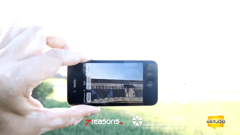
Gif from: https://giphy.com/gifs/wikitude-mobile-ar-l378jIX27GZk8JtMk
However, AR’s use by museum directs to more effective and engaging narration of the exhibition. By the use of AR, more dimensions are added between the physical objects and viewers’ imagination, which enable viewers to establish a more solid understanding to the object, and also a more lively museum experience.
Reference:
Barry, A., et al. “Augmented Reality in a Public Space: The Natural History Museum, London.” Computer, vol. 45, no. 7, 2012, pp. 42–47.
https://www.wikitude.com/blog-augmented-reality-museums/
https://en.wikipedia.org/wiki/Simultaneous_localization_and_mapping
100% of the SBD rewards from this #explore1918 post will support the Philadelphia History Initiative @phillyhistory. This crypto-experiment conducted by graduate courses at Temple University's Center for Public History and MLA Program, is exploring history and empowering education. Click here to learn more.